South China Sea
| South China Sea | |||||||||||
|---|---|---|---|---|---|---|---|---|---|---|---|
 |
|||||||||||
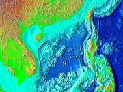
| A map of the South China Sea | |||||||||||
| Chinese name | |||||||||||
| Traditional Chinese | 南海 or 南中國海 | ||||||||||
| Simplified Chinese | 南海 or 南中国海 | ||||||||||
| Hanyu Pinyin | Nán Hǎi or Nán Zhōngguó Hǎi | ||||||||||
|
|||||||||||
| Filipino name | |||||||||||
| Tagalog | Dagat Timog Tsina ('Dagat Luzon' for the portion within Philippine waters) | ||||||||||
| Malay name | |||||||||||
| Malay | Laut China Selatan | ||||||||||
| Portuguese name | |||||||||||
| Portuguese | Mar da China Meridional | ||||||||||
The South China Sea is a marginal sea that is part of the Pacific Ocean, encompassing an area from the Singapore and Malacca Straits to the Strait of Taiwan of around 3,500,000 km². Depending on measurement, it is the largest or second largest body of water after the five oceans.
It is located
- south of China and Taiwan,
- west of the Philippines,
- north west of Sabah (Malaysia), Sarawak (Malaysia) and Brunei,
- north of Indonesia,
- north east of the Malay peninsula (Malaysia) and Singapore, and
- east of Vietnam.
The minute South China Sea Islands, collectively an archipelago, number in the hundreds. The sea and its mostly uninhabited islands are subject to competing claims of sovereignty by several countries. These claims are also reflected in the variety of names used for the islands and the sea.
Contents |
Names for the sea
South China Sea is the dominant term used in English for the sea, and the name in most European languages is equivalent, but it is sometimes called by different names in neighboring countries, often reflecting historical claims to hegemony over the sea.
The English name is a result of early European interest in the sea as a route from Europe and South Asia to the trading opportunities of China. In the sixteenth century Portuguese sailors called it the China Sea (Mar da China); later needs to differentiate it from nearby bodies of water led to calling it the South China Sea.[1]
The International Hydrographic Organization refers to the sea as "South China Sea (Nan Hai)".[2]
It is officially called "East Sea" by the government of Vietnam.[3][4] And the name Biển Đông ("East Sea" in English) is used in its official map.[5]
The part of the South China Sea within Philippine territorial waters is often given the name "Luzon Sea" (Dagat Luzon) in maps published in the country, after the major Philippine island of Luzon. However, the name "South China Sea" (Dagat Timog Tsina) is still the accepted name for the whole sea in the Philippines.
In Southeast Asia, it was once called the Champa Sea or Sea of Cham, after the maritime kingdom that flourished before the sixteenth century.
Geography
States and territories with borders on the sea (clockwise from north) include: the People's Republic of China (including Macau and Hong Kong), the Republic of China (Taiwan), the Philippines, Malaysia, Brunei, Indonesia, Singapore, and Vietnam.
Major rivers that flow into the South China Sea include the Pearl, Min, Jiulong, Red, Mekong, Rajang, Pahang, and Pasig Rivers.
Extent
The International Hydrographic Organization defines the limits of the South China Sea as follows:[2]
On the South. The Eastern and Southern limits of Singapore and Malacca Straits [A line joining Tanjong Datok, the Southeast point of Johore () through Horsburgh Reef to Pulo Koko, the Northeastern extreme of Bintan Island (). The Northeastern coast of Sumatra] as far West as Tanjong Kedabu () down the East coast of Sumatra to Lucipara Point () thence to Tanjong Nanka, the Southwest extremity of Banka Island, through this island to Tanjong Berikat the Eastern point (), on to Tanjong Djemang () in Billiton, along the North coast of this island to Tanjong Boeroeng Mandi () and thence a line to Tanjong Sambar () the Southwest extreme of Borneo.
On the East. From Tanjong Sambar through the West coast of Borneo to Tanjong Sampanmangio, the North point, thence a line to West points of Balabac and Secam Reefs, on to the West point of Bancalan Island and to Cape Buliluyan, the Southwest point of Palawan, through this island to Cabuli Point, the Northern point thereof, thence to the Northwest point of Busuanga and to Cape Calavite in the island of Mindoro, to the Northwest point of Lubang Island and to Point Fuego (14°08'N) in Luzon Island, through this island to Cape Engano, the Northeast point of Luzon, along a line joining this cape with the East point of Balintang Island (20°N) and to the East point of Y'Ami Island (21°05'N) thence to Garan Bi, the Southern point of Taiwan (Formosa), through this island to Santyo (25°N) its North Eastern Point.
On the North. From Fuki Kaku the North point of Formosa to Kiushan Tao (Turnabout Island) on to the South point of Haitan Tao (25°25'N) and thence Westward on the parallel of 25°24' North to the coast of Fukien.
On the West. The Mainland, the Southern limit of the Gulf of Thailand and the East coast of the Malay Peninsula.
Geology
The sea lies above a drowned continental shelf; during recent ice ages global sea level was hundreds of metres lower, and Borneo was part of the Asian mainland.
The South China Sea opened after around 45 million years ago when the Dangerous Grounds were rifted away from southern China. Extension culminated in seafloor spreading around 30 million years ago, a process that propagated to the SW resulting in the V-shaped basin we see today. Extension ceased around 17 million years ago. Arguments have continued about the role of tectonic extrusion in forming the basin. Paul Tapponnier and colleagues have argued that as India collides with Asia it pushes Indochina to the SE. The relative shear between Indochina and China caused the South China Sea to open. This view is disputed by geologists who do not consider Indochina to have moved far relative to mainland Asia. Recent marine geophysical studies by Peter Clift has shown that the Red River Fault was active and causing basin formation at least by 37 million years ago in the NW South China Sea, consistent with extrusion playing a part in the formation of the sea. Since opening the South China Sea has been the repository of large sediment volumes delivered by the Mekong River, Red River and Pearl River. Several of these deltas are rich in oil and gas deposits.
Islands and seamounts
Within the sea, there are over 200 identified islands and reefs, most of them within the Spratly Islands. The Spratly Islands spread over an 810 by 900 km area covering some 175 identified insular features, the largest being Taiping Island (Itu Aba) at just over 1.3 km long and with its highest elevation at 3.8 metres.
The largest singular feature in the area of the Spratly Islands is a 100 km wide seamount called Reed Tablemount, also known as Reed Bank, in the northeast of the group, separated from Palawan Island of the Philippines by the Palawan Trench. Now completely submerged, with a depth of 20 m, it was an island until it sank about 7,000 years ago due to the increasing sea level after the last ice age. With an area of 8,866 km², it is one of the largest submerged atoll structures of the world.
Resources
It is an extremely significant body of water in a geopolitical sense. It is the second most used sea lane in the world, while in terms of world annual merchant fleet tonnage, over 50% passes through the Strait of Malacca, the Sunda Strait, and the Lombok Strait. Over 1.6 million m³ (10 million barrels) of crude oil a day are shipped through the Strait of Malacca, where there are regular reports of piracy, but much less frequently than before the mid-20th century.
The region has proven oil reserves of around 1.2 km³ (7.7 billion barrels), with an estimate of 4.5 km³ (28 billion barrels) in total. Natural gas reserves are estimated to total around 7,500 km³ (266 trillion cubic feet).
According to studies made by the Department of Environment and Natural Resources, Philippines, this body of water holds one third of the entire world's marine biodiversity, thereby making it a very important area for the ecosystem.
Territorial claims
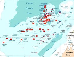
Several countries have made competing territorial claims over the South China Sea. Such disputes have been regarded as Asia's most potentially dangerous point of conflict. Both People's Republic of China (PRC) and the Republic of China (ROC) claim almost the entire body as their own, which claims overlap with virtually every other country in the region. Competing claims include:
- Indonesia, China, and Taiwan over waters NE of the Natuna Islands
- The Philippines, China, and Taiwan over the Malampaya and Camago gas fields.
- The Philippines, China, and Taiwan over Scarborough Shoal.
- Vietnam, China, and Taiwan over waters west of the Spratly Islands. Some or all of the islands themselves are also disputed between Vietnam, China, Taiwan, Brunei, Malaysia, and the Philippines.
- The Paracel Islands are disputed between the PRC/ROC and Vietnam.
- Malaysia, Cambodia, Thailand and Vietnam over areas in the Gulf of Thailand.
- Singapore and Malaysia along the Strait of Johore and the Strait of Singapore.
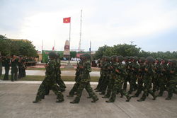
China and Vietnam have both been vigorous in prosecuting their claims. The Paracel Islands were invaded (Vietnam's view) by China in 1974 and 18 soldiers were killed. The Spratly Islands have been the site of a naval clash, in which over seventy Vietnamese sailors were killed just south of Chigua Reef in March 1988. Disputing claimants regularly report clashes between naval vessels.
ASEAN in general, and Malaysia in particular, has been keen to ensure that the territorial disputes within the South China Sea do not escalate into armed conflict. As such, Joint Development Authorities have been set up in areas of overlapping claims to jointly develop the area and dividing the profits equally without settling the issue of sovereignty over the area. This is true, particularly in the Gulf of Thailand. Generally, China has preferred to resolve competing claims bi-laterally, while ASEAN countries prefer multi-lateral talks, believing that they are disadvantaged in bi-lateral negotations with the much larger China and that because many countries claim the same territory only multilateral talks could effectively resolve the competing claims[1].
The overlapping claims over Pedra Branca or Pulau Batu Putih including neighboring Middle Rocks by both Singapore and Malaysia were settled in 2008 by the International Court of Justice, awarding Pedra Branca/Pulau Batu Puteh to Singapore and Middle Rocks to Malaysia.
See also
- East China Sea
- South China Sea shipwrecks
References
- ↑ Tønnesson, Stein (2005). Locating the South China Sea. In Kratoska, Paul et al., eds. Locating Southeast Asia: geographies of knowledge and politics of space. Singapore: Singapore University Press. p. 203-233.
- ↑ 2.0 2.1 "Limits of Oceans and Seas, 3rd edition". International Hydrographic Organization. 1953. http://www.iho-ohi.net/iho_pubs/standard/S-23/S23_1953.pdf. Retrieved 7 February 2010.
- ↑ "VN and China pledge to maintain peace and stability in East Sea". Socialist Republic of Vietnam Government Web Portal. http://chinhphu.vn/portal/page?_pageid=439,1090459&_dad=portal&_schema=portal&pers_id=1091147&item_id=5147503&p_details=1.
- ↑ "FM Spokesperson on FIR control over East Sea". Embassy of Vietnam in USA. March 11, 2001. http://www.vietnamembassy-usa.org/news/story.php?d=20010311025315.
- ↑ "The Map of Vietnam". Socialist Republic of Vietnam Government Web Portal. http://gis.chinhphu.vn/ShowmapGov.asp?pLayer=vn_hcc.
Further reading
- UNEP (2007). Review of the Legal Aspects of Environmental Management in the South China Sea and Gulf of Thailand. UNEP/GEF/SCS Technical Publication No. 9.
- Zou, Keyan (2005). Law of the sea in East Asia: issues and prospects. London/New York: RoutledgeCurzon. ISBN 0-415-35074-3
External links
- The South China Sea on Google Earth - featured on Google Earth's Official Blog
- South China Sea Virtual Library - online resource for students, scholars and policy-makers interested in South China Sea regional development, environment, and security issues.
- Energy Information Administration - The South China Sea
- Tropical Research and Conservation Centre - The South China Sea
- Weekly Piracy Report
- Reversing Environmental Degradation Trends in the South China Sea and Gulf of Thailand
- UNEP/GEF South China Sea Knowledge Documents
|
|||||
|
||||||||||||||
|
||||||||||||||||||||